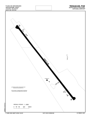


MMHC - Tehuacan
Located in Tehuacan, Mexico
ICAO - MMHC, IATA - TCN
Data provided by AirmateGeneral information
Coordinates: N18°30'0" W97°25'0"
Elevation is 5509 feet MSL.
Magnetic variation is 3° East View others Airports in Puebla
Operational data
Special qualification required
Current time UTC:
Current local time:
Weather at : - ( 0 km )
METAR: PAFS 290801Z AUTO 06005KT 10SM CLR 03/M04 A2993 RMK AO2 SLP143 T00331044
Communications frequencies: [VIEW]
Runways:
| RWY identifier | QFU | Length (ft) | Width (ft) | Surface | LDA (ft) |
| 13 | 143° | 6562 | 112 | ASP | |
| 31 | 323° | 6562 | 112 | ASP |
Airport contact information
Address: Tehuacan Mexico