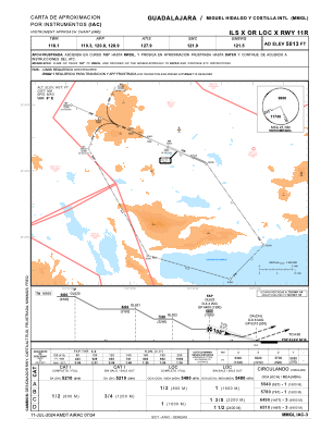
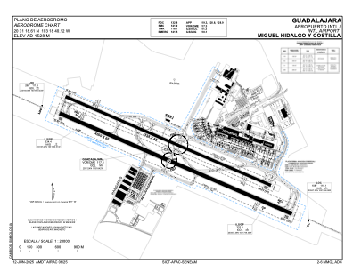


MMGL - Guadalajara Aeropuerto Int. Miguel Hidalgo Y Costilla
Located in Guadalajara, Mexico
ICAO - MMGL, IATA - GDL
Data provided by AirmateGeneral information
Coordinates: N20°31'19" W103°18'40"
Elevation is 5016 feet MSL.
View others Airports in Jalisco
Operational data
Special qualification required
Current time UTC:
Current local time:
Weather
METAR: MMGL 272044Z 30023KT 10SM SCT300 31/M09 A3004 RMK SLP056 57020 959 8/002
TAF: TAF MMGL 271652Z 2718/2818 23012KT P6SM SCT100 SCT250 TX31/2722Z TN11/2812Z FM280600 00000KT P6SM SCT250 FM281800 26016KT P6SM SCT100 SCT250
Communications frequencies: [VIEW]
Runways:
| RWY identifier | QFU | Length (ft) | Width (ft) | Surface | LDA (ft) |
| 02 | 30° | 5906 | 98 | ASP | |
| 20 | 210° | 5906 | 98 | ASP | |
| 11 | 114° | 13123 | 197 | UNK | |
| 29 | 294° | 13123 | 197 | UNK |
Airport contact information
Address: Guadalajara Mexico