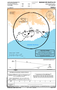
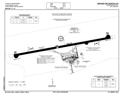


MMBT - Bahias De Huatulco Aeropuerto Internacional
Located in Santa Cruz Huatulco, Mexico
ICAO - MMBT, IATA - HUX
Data provided by AirmateGeneral information
Coordinates: N15°46'31" W96°15'45"
Elevation is 464 feet MSL.
View others Airports in Oaxaca
Operational data
Special qualification required
Current time UTC:
Current local time:
Weather
TAF: TAF MMBT 280421Z 2806/2906 25005KT 6SM HZ SKC FM281800 24010KT P6SM SCT030 FM290400 24005KT 6SM HZ SKC
Communications frequencies: [VIEW]
Runways:
| RWY identifier | QFU | Length (ft) | Width (ft) | Surface | LDA (ft) |
| 07 | 79° | 9843 | 148 | ASP | |
| 25 | 259° | 9843 | 148 | ASP |
Airport contact information
Address: Santa Cruz Huatulco Mexico