


MHPR - Palmerola International
Located in Comayagua, Honduras
ICAO - , IATA -
Data provided by AirmateGeneral information
Coordinates: N14°22'57" W87°37'16"
Elevation is 2064 feet MSL.
View others Airports in Comayagua
Operational data
Special qualification required
Current time UTC:
Current local time:
Weather at : MHTG - Toncontin ( 56 km )
METAR: MHTG 281300Z 10003KT 9999 FEW025 22/19 Q1018 A3006 NOSIG
TAF: TAF MHTG 281100Z 2812/2912 VRB03KT 9999 SCT036 TX31/2820Z TN20/2912Z BECMG 2816/2818 18012KT BECMG 2823/2901 VRB05KT SCT034TCU
Communications frequencies: [VIEW]
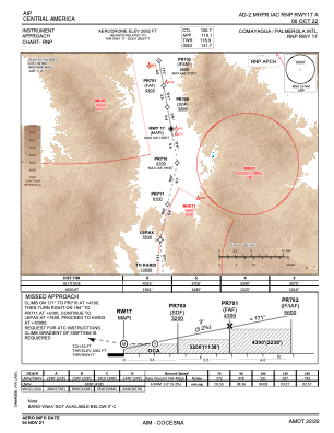
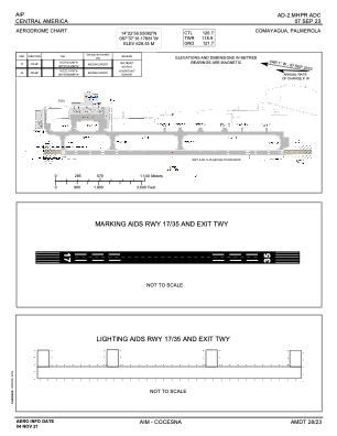
Runways:
| RWY identifier | QFU | Length (ft) | Width (ft) | Surface | LDA (ft) |
| 17 | 170° | 8009 | 148 | UNK | |
| 35 | 350° | 8009 | 148 | UNK |
Airport contact information
Address: Comayagua Honduras