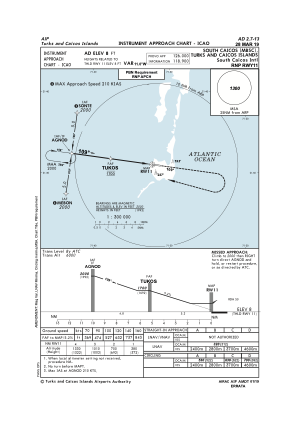


MBSC - South Caicos Intl
Located in Cockburn Harbour, Turks and Caicos Islands
ICAO - MBSC, IATA - XSC
Data provided by AirmateGeneral information
Coordinates: N21°30'57" W71°31'43"
Elevation is 8 feet MSL.
Magnetic variation is -10° East View others Airports in South Caicos
Operational data
Special qualification required
Current time UTC:
Current local time:
Weather at : MBGT - Jags Mccartney Intl ( 41 km )
TAF: MBGT 271700Z 2718/2818 08016KT 9999 SCT020 BKN050
Communications frequencies: [VIEW]
Runways:
| RWY identifier | QFU | Length (ft) | Width (ft) | Surface | LDA (ft) |
| 11 | 98° | 6007 | 98 | ASPH | 6007 |
| 29 | 278° | 6007 | 98 | ASPH | 6007 |
Airport contact information
Address: Cockburn Harbour Turks and Caicos Islands