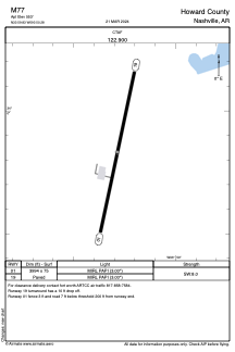


M77 - Howard County
Located in Nashville, United States
ICAO - M77, IATA -
Data provided by AirmateGeneral information
Coordinates: N33°59'50" W93°50'17"
Elevation is 553 feet MSL.
Magnetic variation is 02° East View others Airports in Arkansas
Operational data
Special qualification required
Current time UTC:
Current local time:
Weather at : KDEQ - J Lynn Helms Sevier County ( 52 km )
METAR: KDEQ 050946Z AUTO 23003KT 10SM TS OVC028 19/17 A2992 RMK AO2 LTG DSNT SE-W TSB42 T01940172
Communications frequencies: [VIEW]
Runways:
| RWY identifier | QFU | Length (ft) | Width (ft) | Surface | LDA (ft) |
| 01 | 12° | 3994 | 75 | ASPH | |
| 19 | 192° | 3994 | 75 | ASPH |
Airport contact information
Address: Nashville United States