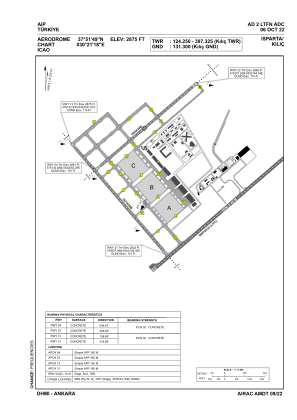


LTFN - Isparta Kilic
Located in Isparta, Turkey
ICAO - , IATA -
Data provided by AirmateGeneral information
Coordinates: N37°51'49" E30°21'18"
Elevation is 2875 feet MSL.
Magnetic variation is 5.1° East View others Airports in Isparta
Operational data
Special qualification required
Current time UTC:
Current local time:
Weather at : LTFC - Isparta Suleyman Demirel ( 1 km )
METAR: LTFC 290750Z 36007KT 300V070 9999 FEW035 22/11 Q1016 RMK RWY23 01006KT 310V080
TAF: TAF LTFC 290440Z 2906/3006 34009KT 9999 SCT035 BECMG 2908/2911 16012KT PROB40 TEMPO 2911/2915 VRB15G25KT -SHRA BKN030 BECMG 2916/2919 02009KT
Communications frequencies: [VIEW]
Runways:
| RWY identifier | QFU | Length (ft) | Width (ft) | Surface | LDA (ft) |
| 04 | 50° | 5397 | 98 | CONC | 5397 |
| 22 | 230° | 5397 | 98 | CONC | 5397 |
| 13 | 140° | 5974 | 98 | CONC | 5974 |
| 31 | 320° | 5974 | 98 | CONC | 5974 |
Airport contact information
Address: Isparta Turkey