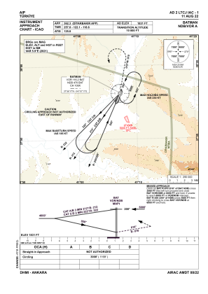
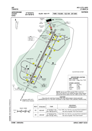


LTCJ - Batman
Located in Batman, Turkey
ICAO - LTCJ, IATA - BAL
Data provided by AirmateGeneral information
Coordinates: N37°55'56" E41°6'59"
Elevation is 1831 feet MSL.
Magnetic variation is 5.9° East View others Airports in Batman
Operational data
Special qualification required
Current time UTC:
Current local time:
Weather
METAR: LTCJ 300120Z 02007KT CAVOK 15/11 Q1013 NOSIG RMK RWY20 36006KT 4CI200
TAF: TAF LTCJ 292240Z 3000/3024 VRB02KT CAVOK BECMG 3005/3008 08015KT FEW040 BKN100 TEMPO 3011/3015 18015G25KT -TSRA FEW025CB BKN035 BKN090
Communications frequencies: [VIEW]
Runways:
| RWY identifier | QFU | Length (ft) | Width (ft) | Surface | LDA (ft) |
| 02 | 26° | 10000 | 148 | CONC | 10000 |
| 20 | 206° | 10000 | 148 | CONC | 10000 |
Airport contact information
Address: Batman Turkey