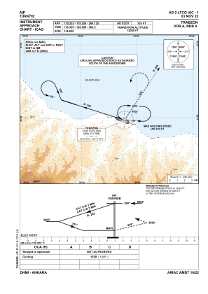
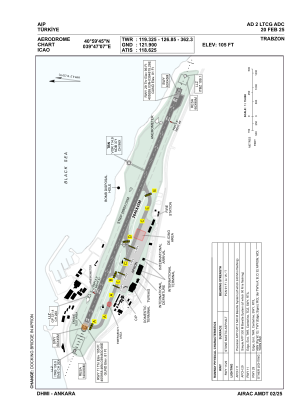


LTCG - Trabzon
Located in Trabzon, Turkey
ICAO - LTCG, IATA - TZX
Data provided by AirmateGeneral information
Coordinates: N40°59'45" E39°47'7"
Elevation is 105 feet MSL.
Magnetic variation is 6.2° East View others Airports in Trabzon
Operational data
Special qualification required
Current time UTC:
Current local time:
Weather
METAR: LTCG 291050Z 20009KT 9999 SCT016 BKN036 20/14 Q1019 NOSIG RMK RWY29 18006KT 130V230
TAF: TAF LTCG 291040Z 2912/3012 VRB02KT 9999 SCT016 BKN033 BECMG 2912/2915 BKN012 BKN028 TEMPO 2915/2919 3500 BR BKN006 BKN026 TEMPO 2919/2922 2500 -DZ BR BKN003 BKN023 BECMG 2922/3002 BKN006 BKN025 TEMPO 3002/3006 2500 -DZ BR BKN003 BKN023 TEMPO 3006/3010 3500 -DZ BR BKN004 BKN024 BECMG 3010/3012 BKN012 BKN028
Communications frequencies: [VIEW]
Runways:
| RWY identifier | QFU | Length (ft) | Width (ft) | Surface | LDA (ft) |
| 11 | 112° | 8661 | 148 | ASPH | 8661 |
| 29 | 292° | 8661 | 148 | ASPH | 8661 |
Airport contact information
Address: Trabzon Turkey