


LTBW - Istanbul Hezarfen
Located in Istanbul, Turkey
ICAO - LTBW, IATA -
Data provided by AirmateGeneral information
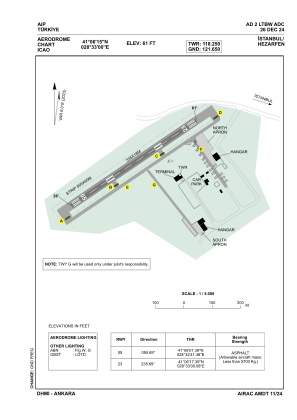
Coordinates: N41°6'15" E28°33'0"
Elevation is 61 feet MSL.
Magnetic variation is 6.0° East View others Airports in Istanbul
Operational data
Special qualification required
Current time UTC:
Current local time:
Weather at : LTFM - Istanbul ( 25 km )
METAR: LTFM 021850Z 24004KT 190V320 9999 BKN033 14/10 Q1012 NOSIG
TAF: TAF LTFM 021640Z 0218/0324 VRB02KT 9999 BKN032 BECMG 0221/0224 2000 BCFG BKN004 BKN020 TEMPO 0300/0303 0400 FG BKN002 BKN020 BECMG 0303/0306 9999 NSW BKN011 BKN022 BECMG 0306/0309 -SHRA SCT020 BKN080 PROB40 TEMPO 0314/0318 34012KT -TSRA FEW017CB BKN025
Communications frequencies: [VIEW]
Runways:
| RWY identifier | QFU | Length (ft) | Width (ft) | Surface | LDA (ft) |
| 05 | 56° | 1755 | 59 | ASPH | 1755 |
| 23 | 236° | 1755 | 59 | ASPH | 1755 |
Airport contact information
Address: Istanbul Turkey