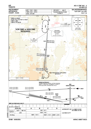
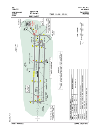


LTBF - Balikesir Merkez
Located in Balikesir, Turkey
ICAO - LTBF, IATA - BZI
Data provided by AirmateGeneral information
Coordinates: N39°37'10" E27°55'34"
Elevation is 340 feet MSL.
Magnetic variation is 5.16° East View others Airports in Balikesir
Operational data
Special qualification required
Current time UTC:
Current local time:
Weather
METAR: LTBF 031650Z 00000KT 9999 SCT035 17/10 Q1006 NOSIG
TAF: TAF LTBF 031640Z 0318/0403 23008KT 9999 SCT035
Communications frequencies: [VIEW]
Runways:
| RWY identifier | QFU | Length (ft) | Width (ft) | Surface | LDA (ft) |
| 18 | 182° | 9810 | 148 | CONC+ASPH | 9810 |
| 36 | 2° | 9810 | 148 | CONC+ASPH | 9810 |
Airport contact information
Address: Balikesir Turkey