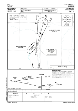


LTAL - Kastamonu
Located in Kastamonu, Turkey
ICAO - LTAL, IATA - KFS
Data provided by AirmateGeneral information
Coordinates: N41°19'1" E33°47'46"
Elevation is 3524 feet MSL.
Magnetic variation is 5.9° East View others Airports in Kastamonu
Operational data
Special qualification required
Current time UTC:
Current local time:
Weather
METAR: LTAL 291950Z 03008KT 6000 OVC003 13/13 Q1021
TAF: TAF LTAL 291340Z 2915/2924 04009KT 7000 -SHRA SCT008 BKN028 TEMPO 2915/2918 28015G25KT 2800 TSRA BKN006 SCT018CB BKN028
Communications frequencies: [VIEW]
Runways:
| RWY identifier | QFU | Length (ft) | Width (ft) | Surface | LDA (ft) |
| 18 | 187° | 7382 | 148 | ASPH | 7382 |
| 36 | 7° | 7382 | 148 | ASPH | 7382 |
Airport contact information
Address: Kastamonu Turkey