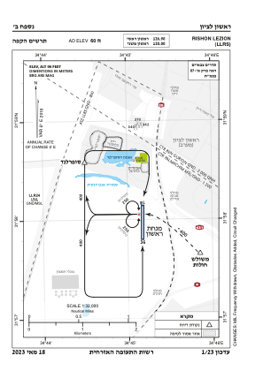
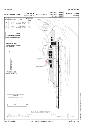


LLRS - Rishon Lezion
Located in ראשל"צ, Israel
ICAO - , IATA -
Data provided by AirmateGeneral information
Coordinates: N31°58'3" E34°45'13"
Elevation is 60 feet MSL.
Magnetic variation is 5° East View others Airports in Center District
Operational data
Special qualification required
Current time UTC:
Current local time:
Weather at : LLBG - Tel-Aviv/Ben-Gurion ( 13 km )
METAR: LLBG 282220Z VRB02KT 9999 BKN013 21/19 Q1011 NOSIG
TAF: TAF LLBG 281704Z 2818/2918 VRB04KT 9999 SCT017 PROB40 TEMPO 2822/2905 17005KT BKN013 BECMG 2907/2909 30010KT SCT030 TX26/2911Z TN20/2904Z
Communications frequencies: [VIEW]
Runways:
| RWY identifier | QFU | Length (ft) | Width (ft) | Surface | LDA (ft) |
| 36 | 360° | 0 | 0 | UNK | |
| 18 | 180° | 0 | 0 | UNK |
Airport contact information
Address: ראשל"צ Israel