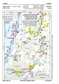
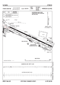


LLHZ - Herzelia Domestic Airport
Located in Herzliya, Israel
ICAO - LLHZ, IATA -
Data provided by AirmateGeneral information
Coordinates: N32°10'50" E34°50'5"
Elevation is 121 feet MSL.
Magnetic variation is 5° East View others Airports in Tel Aviv District
Operational data
Special qualification required
Current time UTC:
Current local time:
Weather
TAF: TAF LLHZ 290504Z 2906/3006 VRB04KT 9999 FEW020 BKN025 PROB40 TEMPO 2906/2907 18005KT SCT015 BKN018 BECMG 2907/2909 30010KT SCT025 BECMG 2916/2918 VRB04KT SCT020 PROB40 TEMPO 2918/3006 BKN015 TX24/2911Z TN20/3004Z
Communications frequencies: [VIEW]
Runways:
| RWY identifier | QFU | Length (ft) | Width (ft) | Surface | LDA (ft) |
| 11 | 110° | 2963 | 59 | Asphalt | |
| 29 | 290° | 2963 | 59 | Asphalt |
Airport contact information
Address: Herzliya Israel
