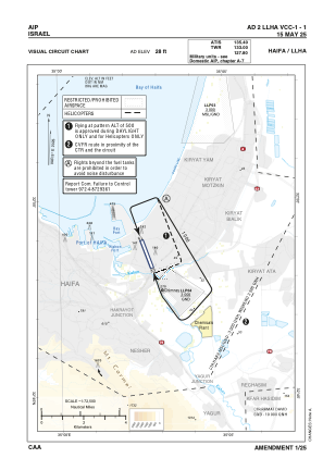
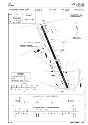


LLHA - Haifa
Located in Haifa, Israel
ICAO - LLHA, IATA - HFA
Data provided by AirmateGeneral information
Coordinates: N32°48'30" E35°2'34"
Elevation is 28 feet MSL.
Magnetic variation is 5° East View others Airports in Haifa District
Operational data
Special qualification required
Current time UTC:
Current local time:
Weather
METAR: LLHA 051850Z 26005KT 9999 FEW040 19/14 Q1009
TAF: TAF LLHA 051708Z 0518/0618 24007KT 9999 SCT025 BKN030 TEMPO 0518/0524 24015G25KT 7000 RA FEW020TCU BKN025 PROB40 TEMPO 0600/0613 22018G28KT 6000 TSRA FEW020CB BKN030 PROB40 TEMPO 0613/0618 26012KT SCT030 TX20/0610Z TN17/0603Z
Communications frequencies: [VIEW]
Runways:
| RWY identifier | QFU | Length (ft) | Width (ft) | Surface | LDA (ft) |
| 16 | 160° | 4324 | 98 | ASPH | 3734 |
| 34 | 340° | 4324 | 98 | ASPH | 3553 |
Airport contact information
Address: Haifa Israel