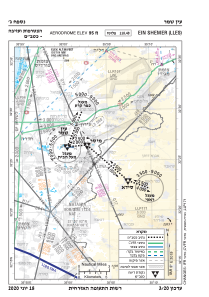


LLES - Ein Shemer
Located in Ein Shemer, Israel
ICAO - LLES, IATA -
Data provided by AirmateGeneral information
Coordinates: N32°26'27" E35°0'12"
Elevation is 95 feet MSL.
Magnetic variation is 5° East View others Airports in North District
Operational data
Special qualification required
Current time UTC:
Current local time:
Weather at : LLHZ - Herzelia Domestic Airport ( 33 km )
TAF: TAF LLHZ 010503Z 0106/0206 VRB04KT 9999 FEW020 SCT030 BECMG 0107/0109 26010KT BECMG 0115/0117 VRB04KT SCT025 TEMPO 0117/0206 19005KT BKN020 TX24/0111Z TN20/0204Z
Communications frequencies: [VIEW]
Runways:
| RWY identifier | QFU | Length (ft) | Width (ft) | Surface | LDA (ft) |
| 10 | 0° | 4265 | 92 | UNK | |
| 28 | 0° | 4265 | 92 | UNK | |
| 10 | 0° | 0 | 0 | UNK | |
| 28 | 0° | 0 | 0 | UNK |
Airport contact information
Address: Ein Shemer Israel