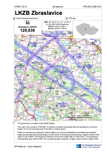


LKZB - Zbraslavice
Located in Zbraslavice, Czech Republic
ICAO - LKZB, IATA -
Data provided by AirmateGeneral information
Coordinates: N49°48'51" E15°12'6"
Elevation is 1618 feet MSL.
View others Airports in Central Bohemian Region
Operational data
Special qualification required
Current time UTC:
Current local time:
Weather at : LKCV - Caslav ( 19 km )
METAR: LKCV 281500Z 15011KT CAVOK 21/07 Q1015 NOSIG RMK BLU BLU
TAF: TAF LKCV 281100Z 2812/2912 14010KT CAVOK TEMPO 2812/2817 16016KT BECMG 2819/2821 13005KT
Communications frequencies: [VIEW]
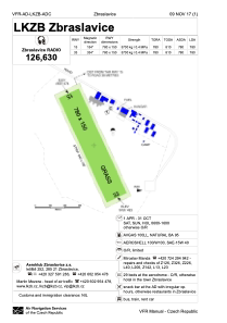
Runways:
| RWY identifier | QFU | Length (ft) | Width (ft) | Surface | LDA (ft) |
| 15 | 0° | 2559 | 262 | GRASS | |
| 33 | 0° | 2559 | 262 | GRASS |
Airport contact information
Address: Zbraslavice Czech Republic
