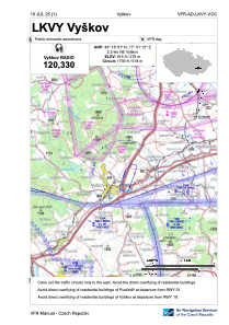
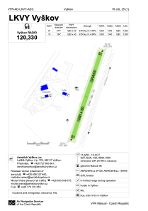


LKVY - Vyskov
Located in Vyskov, Czech Republic
ICAO - LKVY, IATA -
Data provided by AirmateGeneral information
Coordinates: N49°18'1" E17°1'31"
Elevation is 915 feet MSL.
View others Airports in South Moravian Region
Operational data
Special qualification required
Current time UTC:
Current local time:
Weather at : LKTB - Brno/Turany ( 29 km )
METAR: LKTB 272300Z 10011KT CAVOK 11/06 Q1015 NOSIG
TAF: TAF LKTB 271700Z 2718/2818 14010KT CAVOK TEMPO 2809/2816 16016G28KT
Communications frequencies: [VIEW]
Runways:
| RWY identifier | QFU | Length (ft) | Width (ft) | Surface | LDA (ft) |
| 02 | 0° | 4199 | 197 | GRASS | |
| 20 | 0° | 4199 | 197 | GRASS |
Airport contact information
Address: Vyskov Czech Republic

