


LKVRAT - Vratkov
Located in Český Brod, Czech Republic
ICAO - , IATA -
Data provided by AirmateGeneral information
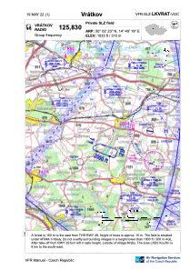
Coordinates: N50°2'26" E14°49'8"
Elevation is 1033 feet MSL.
View others Airports in Prague (capital city)
Operational data
Special qualification required
Current time UTC:
Current local time:
Weather at : LKKB - Kbely ( 22 km )
METAR: LKKB 301700Z 12017KT CAVOK 24/06 Q1015 NOSIG
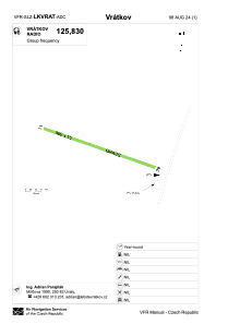
Communications frequencies: [VIEW]
Runways:
| RWY identifier | QFU | Length (ft) | Width (ft) | Surface | LDA (ft) |
| 11 | 111° | 1903 | 49 | GRASS | 1903 |
| 29 | 291° | 1903 | 49 | GRASS | 1903 |
Airport contact information
Address: Český Brod Czech Republic