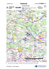
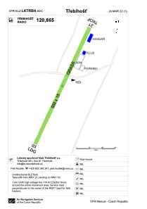


LKTRBH - Trebihost
Located in , Czech Republic
ICAO - , IATA -
Data provided by AirmateGeneral information
Coordinates: N50°26'7" E15°41'35"
Elevation is 1624 feet MSL.
View others Airports in Hradec Králové Region
Operational data
Special qualification required
Current time UTC:
Current local time:
Weather at : LKPD - Pardubice ( 47 km )
METAR: LKPD 021800Z 11010KT 9999 FEW045 19/11 Q1005 NOSIG RMK BLU BLU
TAF: TAF LKPD 021700Z 0218/0318 12014KT CAVOK BECMG 0223/0301 12008KT TEMPO 0308/0315 14014G24KT 7000 SHRA SCT030TCU BKN040
Communications frequencies: [VIEW]
Runways:
| RWY identifier | QFU | Length (ft) | Width (ft) | Surface | LDA (ft) |
| 03 | 29° | 1640 | 49 | GRASS | 1772 |
| 21 | 209° | 1640 | 49 | GRASS |
Airport contact information
Address: Czech Republic