


LKTD - Tachov
Located in Tachov, Czech Republic
ICAO - LKTD, IATA -
Data provided by AirmateGeneral information
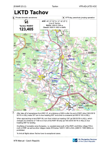
Coordinates: N49°47'52" E12°42'25"
Elevation is 1639 feet MSL.
View others Airports in Plzen Region
Operational data
Special qualification required
Current time UTC:
Current local time:
Weather at : LKLN - Plzen/Line ( 43 km )
METAR: LKLN 020200Z AUTO 11005KT 070V150 9999 // NCD 14/09 Q1005
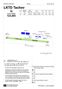
Communications frequencies: [VIEW]
Runways:
| RWY identifier | QFU | Length (ft) | Width (ft) | Surface | LDA (ft) |
| 09 | 0° | 3609 | 75 | UNK | |
| 27 | 0° | 3609 | 75 | UNK |
Airport contact information
Address: Tachov Czech Republic