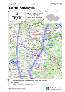


LKRK - Rakovnik
Located in Rakovnik, Czech Republic
ICAO - LKRK, IATA -
Data provided by AirmateGeneral information
Coordinates: N50°5'39" E13°41'20"
Elevation is 1273 feet MSL.
View others Airports in Central Bohemian Region
Operational data
Special qualification required
Current time UTC:
Current local time:
Weather at : LKPR - Praha/Ruzyne ( 41 km )
METAR: LKPR 280530Z VRB01KT CAVOK 09/06 Q1013 NOSIG
TAF: TAF LKPR 280500Z 2806/2912 13004KT CAVOK BECMG 2809/2811 15010KT BECMG 2823/2901 33005KT BECMG 2907/2909 06005KT
Communications frequencies: [VIEW]
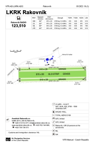
Runways:
| RWY identifier | QFU | Length (ft) | Width (ft) | Surface | LDA (ft) |
| 09R | 0° | 2986 | 66 | GRASS | |
| 27L | 0° | 2986 | 66 | GRASS | |
| 09L | 0° | 2986 | 66 | GRASS | |
| 27R | 0° | 2986 | 66 | GRASS |
Airport contact information
Address: Rakovnik Czech Republic