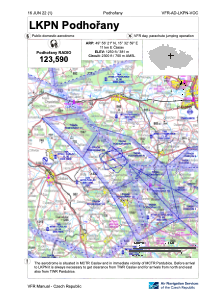
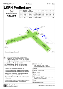


LKPN - Podhorany
Located in Caslav, Czech Republic
ICAO - LKPN, IATA -
Data provided by AirmateGeneral information
Coordinates: N49°56'21" E15°32'59"
Elevation is 1250 feet MSL.
View others Airports in Pardubice Region
Operational data
Special qualification required
Current time UTC:
Current local time:
Weather at : LKCV - Caslav ( 12 km )
METAR: LKCV 301930Z 11009KT CAVOK 20/07 Q1017 NOSIG RMK BLU BLU
TAF: TAF LKCV 301700Z 3018/0118 14016KT CAVOK TEMPO 3020/0108 12011KT TEMPO 0110/0115 15021G31KT PROB30 TEMPO 0110/0113 15026KT
Communications frequencies: [VIEW]
Runways:
| RWY identifier | QFU | Length (ft) | Width (ft) | Surface | LDA (ft) |
| 13 | 128° | 2100 | 302 | Grass | |
| 31 | 308° | 2100 | 302 | Grass | |
| 07 | 69° | 2395 | 246 | Grass | |
| 25 | 249° | 2395 | 246 | Grass |
Airport contact information
Address: Caslav Czech Republic
