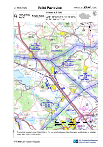


LKPAVL - Velké Pavlovice
Located in Velké Pavlovice, Czech Republic
ICAO - , IATA -
Data provided by AirmateGeneral information
Coordinates: N48°52'50" E16°49'29"
Elevation is 564 feet MSL.
Magnetic variation is 4° East View others Airports in South Moravian Region
Operational data
Special qualification required
Current time UTC:
Current local time:
Weather at : LKTB - Brno/Turany ( 32 km )
METAR: LKTB 280100Z 10014KT CAVOK 11/05 Q1014 NOSIG
TAF: TAF LKTB 272300Z 2800/2900 12010KT CAVOK TEMPO 2809/2816 16016G26KT
Communications frequencies: [VIEW]
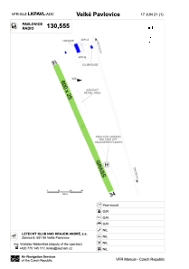
Runways:
| RWY identifier | QFU | Length (ft) | Width (ft) | Surface | LDA (ft) |
| 16 | 155° | 1969 | 82 | GRASS | 1969 |
| 34 | 335° | 1969 | 82 | GRASS | 1969 |
Airport contact information
Address: Velké Pavlovice Czech Republic