


LKMIRO - Miroslav
Located in Miroslav, Czech Republic
ICAO - , IATA -
Data provided by AirmateGeneral information
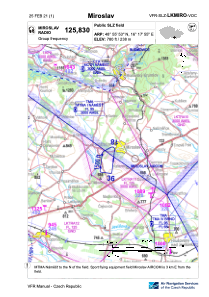
Coordinates: N48°55'53" E16°17'55"
Elevation is 780 feet MSL.
View others Airports in South Moravian Region
Operational data
Special qualification required
Current time UTC:
Current local time:
Weather at : LKNA - Namest ( 29 km )
METAR: LKNA 280430Z 12010KT CAVOK 07/05 Q1014 NOSIG RMK BLU BLU
TAF: TAF LKNA 272300Z 2800/2900 11010KT CAVOK TEMPO 2806/2820 14017KT
Communications frequencies: [VIEW]
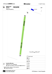
Runways:
| RWY identifier | QFU | Length (ft) | Width (ft) | Surface | LDA (ft) |
| 18 | 9° | 1969 | 82 | GRASS | 1969 |
| 36 | 189° | 1969 | 82 | GRASS | 1969 |
Airport contact information
Address: Miroslav Czech Republic