


LKKUNE - Kunetice
Located in Pardubice, Czech Republic
ICAO - , IATA -
Data provided by AirmateGeneral information
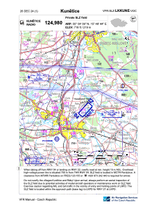
Coordinates: N50°4'8" E15°48'48"
Elevation is 718 feet MSL.
View others Airports in Pardubice Region
Operational data
Special qualification required
Current time UTC:
Current local time:
Weather at : LKPD - Pardubice ( 8 km )
METAR: LKPD 301630Z 14016KT CAVOK 24/06 Q1018 NOSIG RMK BLU BLU
TAF: TAF LKPD 301100Z 3012/0112 14015KT CAVOK TEMPO 3012/3021 16018G30KT TEMPO 0100/0106 09008KT
Communications frequencies: [VIEW]
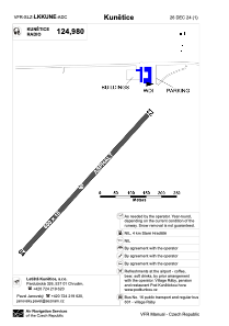
Runways:
| RWY identifier | QFU | Length (ft) | Width (ft) | Surface | LDA (ft) |
| 05 | 43° | 1969 | 49 | ASPH | 1969 |
| 23 | 223° | 1969 | 49 | ASPH | 1969 |
Airport contact information
Address: Pardubice Czech Republic