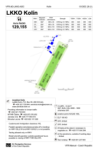


LKKO - Kolin
Located in Kolin, Czech Republic
ICAO - LKKO, IATA -
Data provided by AirmateGeneral information
Coordinates: N50°0'7" E15°10'24"
Elevation is 925 feet MSL.
View others Airports in Central Bohemian Region
Operational data
Special qualification required
Current time UTC:
Current local time:
Weather at : LKCV - Caslav ( 16 km )
TAF: TAF LKCV 271100Z 2712/2812 16012KT CAVOK TEMPO 2712/2716 14016KT PROB40 TEMPO 2718/2806 11008KT
Communications frequencies: [VIEW]
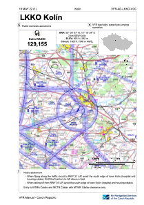
Runways:
| RWY identifier | QFU | Length (ft) | Width (ft) | Surface | LDA (ft) |
| 03L | 0° | 2953 | 361 | GRASS | |
| 21R | 0° | 2953 | 361 | GRASS | |
| 03R | 0° | 2953 | 115 | GRASS | |
| 21L | 0° | 2953 | 115 | GRASS |
Airport contact information
Address: Kolin Czech Republic

