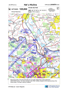
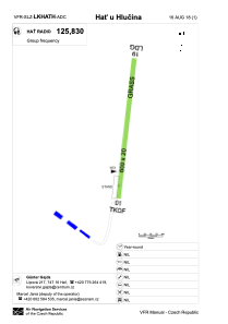


LKHATH - Hat U Hlucina
Located in Hlučín, Czech Republic
ICAO - , IATA -
Data provided by AirmateGeneral information
Coordinates: N49°57'0" E18°15'53"
Elevation is 774 feet MSL.
View others Airports in Moravian-Silesian Region
Operational data
Special qualification required
Current time UTC:
Current local time:
Weather at : LKMT - Ostrava/Mosnov ( 30 km )
METAR: LKMT 040530Z VRB01KT CAVOK 14/11 Q1015 NOSIG
TAF: TAF LKMT 040500Z 0406/0506 VRB02KT CAVOK BECMG 0406/0408 03006KT PROB30 TEMPO 0413/0416 7000 -SHRA SCT040TCU BECMG 0420/0422 21005KT
Communications frequencies: [VIEW]
Runways:
| RWY identifier | QFU | Length (ft) | Width (ft) | Surface | LDA (ft) |
| 01 | 9° | 1969 | 66 | GRASS | |
| 19 | 189° | 1969 | 66 | GRASS | 1969 |
Airport contact information
Address: Hlučín Czech Republic