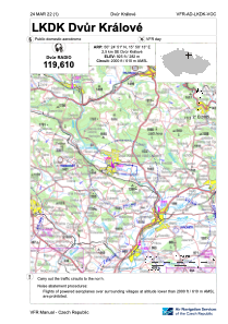
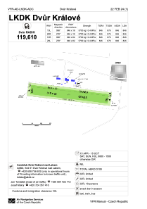


LKDK - Dvur Kralove
Located in Dvur Kralove Nad Labem, Czech Republic
ICAO - LKDK, IATA -
Data provided by AirmateGeneral information
Coordinates: N50°24'51" E15°50'13"
Elevation is 925 feet MSL.
View others Airports in Hradec Králové Region
Operational data
Special qualification required
Current time UTC:
Current local time:
Weather at : LKPD - Pardubice ( 45 km )
METAR: LKPD 030200Z 07004KT CAVOK 12/10 Q1006 RMK BLU
TAF: TAF LKPD 022300Z 0300/0400 12008KT CAVOK TEMPO 0308/0315 14014G24KT 7000 SHRA SCT030TCU BKN040 PROB30 TEMPO 0310/0314 5000 TSRA BKN020CB
Communications frequencies: [VIEW]
Runways:
| RWY identifier | QFU | Length (ft) | Width (ft) | Surface | LDA (ft) |
| 10R | 0° | 2776 | 269 | UNK | |
| 28L | 0° | 2776 | 269 | UNK | |
| 10L | 0° | 2776 | 59 | UNK | |
| 28R | 0° | 2776 | 59 | UNK |
Airport contact information
Address: Dvur Kralove Nad Labem Czech Republic
