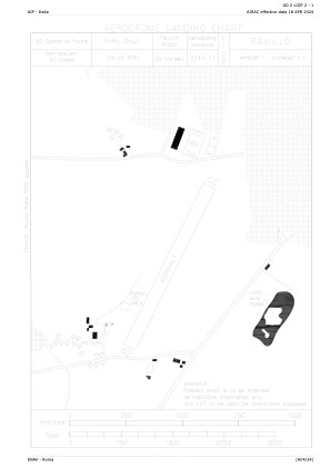


LIDP - Pavullo
Located in , Italy
ICAO - LIDP, IATA -
Data provided by AirmateGeneral information
Coordinates: N44°19'20" E10°49'54"
Elevation is 2244 feet MSL.
View others Airports in Emilia-Romagna
Operational data
Special qualification required
Current time UTC:
Current local time:
Weather at : LIPE - Bologna/Borgo Panigale ( 44 km )
METAR: LIPE 050950Z VRB03KT 9999 FEW040 21/12 Q1015
TAF: TAF LIPE 050500Z 0506/0606 VRB05KT 9999 FEW050
Communications frequencies: [VIEW]
Runways:
| RWY identifier | QFU | Length (ft) | Width (ft) | Surface | LDA (ft) |
| 02 | 0° | 3904 | 75 | ASPH | |
| 20 | 0° | 3904 | 75 | ASPH |
Airport contact information
Address: Italy
