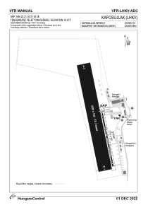
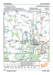


LHKV - Kaposujlak
Located in Kaposvar, Hungary
ICAO - LHKV, IATA -
Data provided by AirmateGeneral information
Coordinates: N46°23'21" E17°43'58"
Elevation is 512 feet MSL.
Magnetic variation is 3.4° East View others Airports in Somogy
Operational data
Special qualification required
Current time UTC:
Current local time:
Weather at : LHSM - Heviz-Balaton Airport ( 55 km )
METAR: LHSM 011715Z AUTO 01002KT CAVOK 19/14 Q1011
TAF: TAF LHSM 011115Z 0112/0121 12008KT CAVOK PROB40 TEMPO 0115/0121 VRB15G25KT 8000 -SHRA SCT050TCU BKN083 PROB30 TEMPO 0118/0121 4500 TSRA SHRA SCT050CB BKN070
Communications frequencies: [VIEW]
Runways:
| RWY identifier | QFU | Length (ft) | Width (ft) | Surface | LDA (ft) |
| 17L | 0° | 2034 | 59 | CONC | |
| 35R | 0° | 2034 | 59 | CONC | |
| 17R | 0° | 3937 | 492 | GRASS | |
| 35L | 0° | 3937 | 492 | GRASS |
Airport contact information
Address: Kaposvar Hungary
