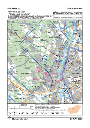
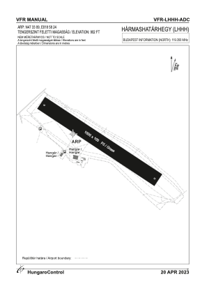


LHHH - Harmashatarhegy
Located in Budapest, Hungary
ICAO - LHHH, IATA -
Data provided by AirmateGeneral information
Coordinates: N47°33'1" E18°58'24"
Elevation is 902 feet MSL.
Magnetic variation is 5° East View others Airports in Budapest
Operational data
Special qualification required
Current time UTC:
Current local time:
Weather at : LHBP - Budapest/Liszt Ferenc International Airport ( 25 km )
METAR: LHBP 040530Z 34009KT CAVOK 14/10 Q1011 NOSIG
TAF: TAF LHBP 040515Z 0406/0506 34008KT CAVOK BECMG 0406/0409 06008KT BECMG 0413/0416 VRB03KT TEMPO 0415/0421 FEW070CB
Communications frequencies: [VIEW]
Runways:
| RWY identifier | QFU | Length (ft) | Width (ft) | Surface | LDA (ft) |
| 13 | 0° | 3281 | 328 | GRASS | |
| 31 | 0° | 3281 | 328 | GRASS |
Airport contact information
Address: Budapest Hungary