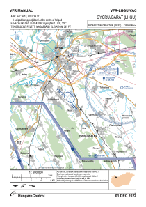
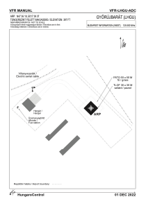


LHGU - Gyorujbarat
Located in Gyorujbarat, Hungary
ICAO - , IATA -
Data provided by AirmateGeneral information
Coordinates: N47°36'18" E17°39'37"
Elevation is 397 feet MSL.
View others Airports in Gyor-Moson-Sopron
Operational data
Special qualification required
Current time UTC:
Current local time:
Weather at : LHPR - Gyor/Per ( 11 km )
METAR: LHPR 300245Z AUTO 10006KT CAVOK 09/08 Q1024
TAF: TAF LHPR 300215Z 3003/3012 11005KT CAVOK BECMG 3007/3010 14011KT
Communications frequencies: [VIEW]
Runways:
Airport contact information
Address: Gyorujbarat Hungary