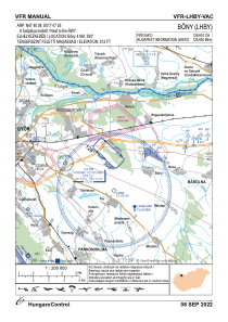


LHBY - Bony
Located in Bony, Hungary
ICAO - , IATA -
Data provided by AirmateGeneral information
Coordinates: N47°40'8" E17°47'5"
Elevation is 512 feet MSL.
View others Airports in Gyor-Moson-Sopron
Operational data
Special qualification required
Current time UTC:
Current local time:
Weather at : LHPR - Gyor/Per ( 5 km )
METAR: LHPR 300415Z AUTO 11004KT CAVOK 09/07 Q1024 NOSIG
TAF: TAF LHPR 300215Z 3003/3012 11005KT CAVOK BECMG 3007/3010 14011KT
Communications frequencies: [VIEW]
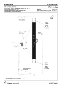
Runways:
| RWY identifier | QFU | Length (ft) | Width (ft) | Surface | LDA (ft) |
| 13 | 0° | 2133 | 197 | GRASS | |
| 31 | 0° | 2133 | 197 | GRASS |
Airport contact information
Address: Bony Hungary