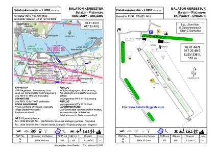


LHBK - Balatonkeresztur
Located in Balatonkeresztur, Hungary
ICAO - , IATA -
Data provided by AirmateGeneral information
Coordinates: N46°41'35" E17°23'51"
Elevation is 361 feet MSL.
Magnetic variation is 5° East View others Airports in Somogy
Operational data
Special qualification required
Current time UTC:
Current local time:
Weather at : LHSM - Heviz-Balaton Airport ( 18 km )
METAR: LHSM 011945Z AUTO 08005KT 050V120 CAVOK 17/11 Q1011
TAF: TAF LHSM 011115Z 0112/0121 12008KT CAVOK PROB40 TEMPO 0115/0121 VRB15G25KT 8000 -SHRA SCT050TCU BKN083 PROB30 TEMPO 0118/0121 4500 TSRA SHRA SCT050CB BKN070
Communications frequencies: [VIEW]
Runways:
| RWY identifier | QFU | Length (ft) | Width (ft) | Surface | LDA (ft) |
| 14 | 139° | 2388 | 137 | GRASS | |
| 32 | 319° | 2388 | 137 | GRASS |
Airport contact information
Address: Balatonkeresztur Hungary