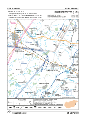
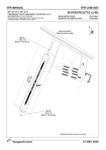


LHBI - Biharkeresztes
Located in Biharkeresztes, Hungary
ICAO - , IATA -
Data provided by AirmateGeneral information
Coordinates: N47°8'12" E21°40'9"
Elevation is 311 feet MSL.
View others Airports in Hajdu-Bihar
Operational data
Special qualification required
Current time UTC:
Current local time:
Weather at : LROD - Oradea ( 22 km )
METAR: LROD 282030Z AUTO 09005KT 9999 NCD 16/09 Q1022
TAF: TAF LROD 281700Z 2818/2903 VRB04KT CAVOK
Communications frequencies: [VIEW]
Runways:
| RWY identifier | QFU | Length (ft) | Width (ft) | Surface | LDA (ft) |
| 02 | 0° | 2133 | 66 | CONC | |
| 20 | 0° | 2133 | 66 | CONC |
Airport contact information
Address: Biharkeresztes Hungary