


LGAX - Alexandria
Located in Alexandria City, Greece
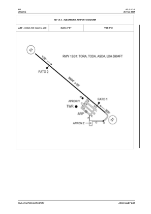
ICAO - LGAX, IATA -
Data provided by AirmateGeneral information
Coordinates: N40°38'47" E22°29'34"
Elevation is 27 feet MSL.
View others Airports in Imathia
Operational data
Special qualification required
Current time UTC:
Current local time:
Weather at : LGTS - Thessaloniki/ Makedonia ( 43 km )
METAR: LGTS 280820Z 29005KT CAVOK 19/11 Q1021 NOSIG
TAF: TAF LGTS 280500Z 2806/2906 VRB03KT CAVOK TEMPO 2812/2818 14013KT
Communications frequencies: [VIEW]
Runways:
| RWY identifier | QFU | Length (ft) | Width (ft) | Surface | LDA (ft) |
| 13 | 128° | 5906 | 98 | ASPH | |
| 31 | 308° | 5906 | 98 | ASPH |
Airport contact information
Address: Alexandria City Greece