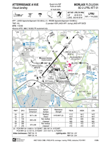
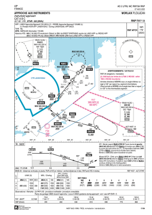
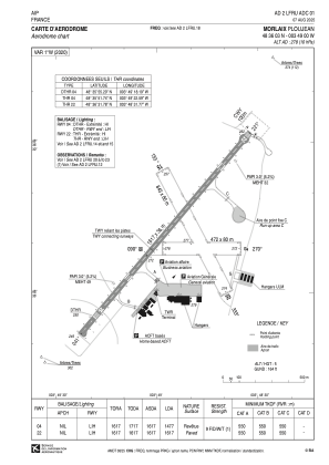


LFRU - Morlaix Ploujean
Located in Morlaix, France
ICAO - LFRU, IATA - MXN
Data provided by AirmateGeneral information
Coordinates: N48°36'3" W3°49'0"
Elevation is 278 feet MSL.
Magnetic variation is -0.94° East View others Airports in Brittany
Operational data
Special qualification required
Current time UTC:
Current local time:
Weather
METAR: LFRU 291000Z AUTO 21014KT 170V240 9999 FEW030 SCT049 14/06 Q1015
Communications frequencies: [VIEW]
Runways:
| RWY identifier | QFU | Length (ft) | Width (ft) | Surface | LDA (ft) |
| 04 | 40° | 5305 | 118 | ASPH | 4846 |
| 22 | 220° | 5305 | 118 | ASPH | 5305 |
| 15 | 152° | 2772 | 262 | GRASS | 2772 |
| 33 | 332° | 2772 | 262 | GRASS | 2772 |
| 09 | 89° | 1549 | 262 | GRASS | 1549 |
| 27 | 269° | 1549 | 262 | GRASS | 1549 |
Airport contact information
Address: Morlaix France

