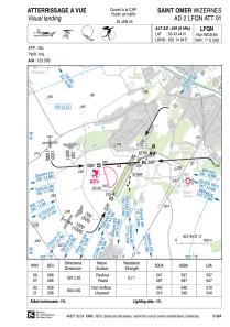


LFQN - Saint Omer Wizernes
Located in Saint-Omer, France
ICAO - LFQN, IATA - XSG
Data provided by AirmateGeneral information
Coordinates: N50°43'44" E2°14'4"
Elevation is 249 feet MSL.
Magnetic variation is 0.88° East View others Airports in Nord-Pas-de-Calais
Operational data
Special qualification required
Current time UTC:
Current local time:
Weather at : LFAC - Calais Marck ( 33 km )
METAR: LFAC 270800Z AUTO 20004KT 150V250 9999 BKN010 BKN016 BKN230 11/09 Q1003
Communications frequencies: [VIEW]
Runways:
| RWY identifier | QFU | Length (ft) | Width (ft) | Surface | LDA (ft) |
| 09 | 87° | 1959 | 66 | ASPH | 1959 |
| 27 | 267° | 1959 | 66 | ASPH | 1795 |
| 03 | 27° | 2100 | 164 | GRASS | 2001 |
| 21 | 207° | 2100 | 164 | GRASS | 1772 |
Airport contact information
Address: Saint-Omer France

