


LFNX - Bedarieux La Tour Sur Orb
Located in , France
ICAO - LFNX, IATA -
Data provided by AirmateGeneral information
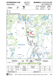
Coordinates: N43°38'23" E3°8'41"
Elevation is 1247 feet MSL.
Magnetic variation is 1.42° East View others Airports in Languedoc-Roussillon
Operational data
Special qualification required
Current time UTC:
Current local time:
Weather at : LFMU - Beziers Vias ( 39 km )
TAF: TAF LFMU 031400Z 0315/0415 19010KT CAVOK BECMG 0317/0319 01005KT BECMG 0411/0413 12010KT
Communications frequencies: [VIEW]
Runways:
| RWY identifier | QFU | Length (ft) | Width (ft) | Surface | LDA (ft) |
| 17 | 173° | 3199 | 197 | GRASS | |
| 35 | 353° | 3199 | 197 | GRASS |
Airport contact information
Address: France
