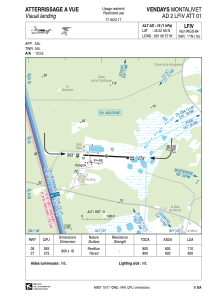


LFIV - Vendays Montalivet
Located in , France
ICAO - LFIV, IATA -
Data provided by AirmateGeneral information
Coordinates: N45°22'50" W1°6'57"
Elevation is 16 feet MSL.
Magnetic variation is 0.19° East View others Airports in Aquitaine
Operational data
Special qualification required
Current time UTC:
Current local time:
Weather at : LFBD - Bordeaux Merignac ( 69 km )
METAR: LFBD 280730Z AUTO 16007KT 9999 FEW048 12/09 Q1012 NOSIG
TAF: TAF LFBD 280500Z 2806/2912 15005KT 9999 BKN040 TX18/2814Z TN07/2806Z BECMG 2808/2810 21010KT SCT030 PROB30 TEMPO 2810/2813 4000 SHRA BKN030TCU BECMG 2815/2817 30010KT CAVOK BECMG 2818/2820 VRB03KT PROB30 TEMPO 2822/2906 1500 MIFG BECMG 2910/2912 BKN030
Communications frequencies: [VIEW]
Runways:
| RWY identifier | QFU | Length (ft) | Width (ft) | Surface | LDA (ft) |
| 09 | 93° | 2625 | 59 | ASPH | |
| 27 | 273° | 2625 | 59 | ASPH |
Airport contact information
Address: France
