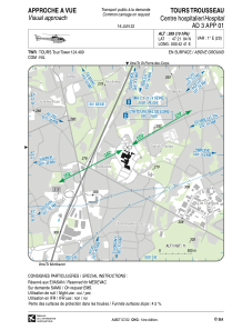


LFH366 - Tours Trousseau 2
Located in , France
ICAO - , IATA -
Data provided by AirmateGeneral information
Coordinates: N47°21'4" E0°42'41"
Elevation is 269 feet MSL.
Magnetic variation is 0.61° East View others Airports in Centre
Operational data
Special qualification required
Current time UTC:
Current local time:
Weather at : LFOT - Tours Val De Loire ( 9 km )
METAR: LFOT 281600Z AUTO 20009KT 9999 ///CB 15/09 Q1014 TEMPO 26015G25KT 4000 -TSRA
TAF: TAF AMD LFOT 281341Z 2813/2912 25010KT 9999 BKN040 TEMPO 2814/2820 -SHRA FEW030TCU PROB40 TEMPO 2814/2817 26015G25KT 4000 SHRA SCT030CB PROB40 TEMPO 2814/2817 -TSRA BECMG 2820/2823 17004KT PROB40 2902/2908 3000 BR PROB30 2903/2906 0900 FG VV///
Communications frequencies: [VIEW]
Runways:
Airport contact information
Address: France