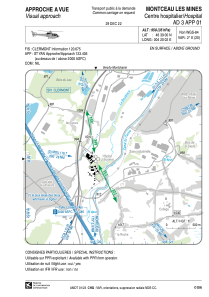


LFH301 - Montceau Les Mines Centre Hospitalier
Located in , France
ICAO - , IATA -
Data provided by AirmateGeneral information
Coordinates: N46°39'0" E4°20'2"
Elevation is 958 feet MSL.
Magnetic variation is 1.67° East View others Airports in Burgundy
Operational data
Special qualification required
Current time UTC:
Current local time:
Weather at : LFLN - Saint Yan ( 36 km )
METAR: LFLN 291200Z AUTO 09003KT 070V130 8000 -RA BKN008/// BKN015/// OVC068/// //////TCU 13/11 Q1020 TEMPO FEW030TCU
TAF: TAF LFLN 291100Z 2912/2921 09005KT 9999 FEW020 BKN070 TEMPO 2912/2921 -RA FEW030TCU
Communications frequencies: [VIEW]
Runways:
Airport contact information
Address: France