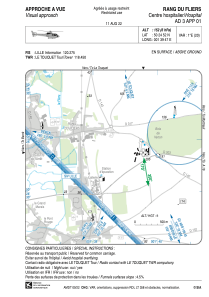


LFH173 - Rang Du Fliers Centre Hospitalier
Located in , France
ICAO - , IATA -
Data provided by AirmateGeneral information
Coordinates: N50°24'52" E1°39'47"
Elevation is 152 feet MSL.
Magnetic variation is 0.72° East View others Airports in Nord-Pas-de-Calais
Operational data
Special qualification required
Current time UTC:
Current local time:
Weather at : LFAT - Le Touquet Cote D'opale ( 11 km )
METAR: LFAT 271100Z AUTO 12008KT 090V150 9999 BKN021 BKN026 OVC110 14/09 Q1002 TEMPO VRB15G25KT 3000 RA SCT008 BKN013 BKN020CB
TAF: TAF AMD LFAT 270829Z 2709/2718 13005KT 9999 FEW010 BKN030 TEMPO 2712/2718 VRB15G25KT 3000 RA SCT008 BKN013 BKN020CB PROB30 TEMPO 2715/2718 1000 TSRA
Communications frequencies: [VIEW]
Runways:
Airport contact information
Address: France