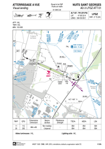


LFGZ - Nuits Saint Georges
Located in , France
ICAO - LFGZ, IATA -
Data provided by AirmateGeneral information
Coordinates: N47°8'32" E4°58'6"
Elevation is 794 feet MSL.
Magnetic variation is 1.83° East View others Airports in Burgundy
Operational data
Special qualification required
Current time UTC:
Current local time:
Weather at : LFSD - Dijon-Longvic ( 17 km )
METAR: LFSD 290900Z AUTO 13004KT 9999 -RA BKN006/// OVC072/// ///TCU 11/10 Q1020
Communications frequencies: [VIEW]
Runways:
| RWY identifier | QFU | Length (ft) | Width (ft) | Surface | LDA (ft) |
| 11 | 114° | 2933 | 197 | GRASS | 2933 |
| 29 | 294° | 2933 | 197 | GRASS | 2933 |
Airport contact information
Address: France

