


LFGU - Sarreguemines Neunkirch
Located in Sarreguemines, France
ICAO - LFGU, IATA -
Data provided by AirmateGeneral information
Coordinates: N49°7'39" E7°6'24"
Elevation is 863 feet MSL.
Magnetic variation is 2.39° East View others Airports in Lorraine
Operational data
Special qualification required
Current time UTC:
Current local time:
Communications frequencies: [VIEW]
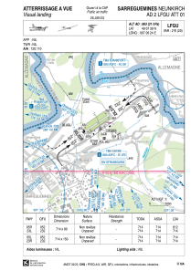
Runways:
| RWY identifier | QFU | Length (ft) | Width (ft) | Surface | LDA (ft) |
| 05R | 54° | 2343 | 262 | GRASS | 2008 |
| 23L | 234° | 2343 | 262 | GRASS | 2343 |
| 05L | 54° | 2343 | 492 | GRASS | 2343 |
| 23R | 234° | 2343 | 492 | GRASS | 2343 |
Airport contact information
Address: Sarreguemines France
Fuel provider

Other aviation service providers
Aviation club (not for profit)

Espoir Aéronautique de Sarreguemines
Espoir Aéronautique de Sarreguemines
espoir.aeronautique@lfgu.fr+33387953350