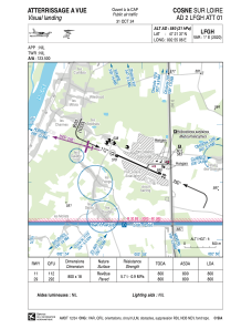


LFGH - Cosne Sur Loire
Located in Cosne, France
ICAO - LFGH, IATA -
Data provided by AirmateGeneral information
Coordinates: N47°21'37" E2°55'6"
Elevation is 580 feet MSL.
Magnetic variation is 1.26° East View others Airports in Burgundy
Operational data
Special qualification required
Current time UTC:
Current local time:
Weather at : LFOA - Avord ( 40 km )
METAR: LFOA 290800Z AUTO 09003KT 9999 FEW005 OVC120 11/10 Q1019 NOSIG
TAF: TAF LFOA 290800Z 2909/3009 VRB02KT CAVOK TX17/2915Z TN11/3005Z TEMPO 2912/2915 12015KT 4000 SHRA SCT014 BKN030TCU BECMG 2915/2917 12010KT 4000 RA SCT012 SCT030TCU BECMG 3007/3009 9999 NSW BKN025
Communications frequencies: [VIEW]
Runways:
| RWY identifier | QFU | Length (ft) | Width (ft) | Surface | LDA (ft) |
| 11 | 115° | 2625 | 59 | ASPH | |
| 29 | 295° | 2625 | 59 | ASPH |
Airport contact information
Address: Cosne France
