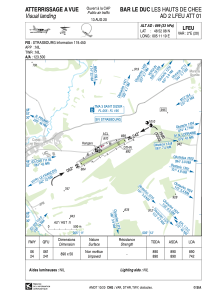


LFEU - Bar Le Duc Les Hauts De Chee
Located in Bar Le Duc, France
ICAO - LFEU, IATA - XBD
Data provided by AirmateGeneral information
Coordinates: N48°52'4" E5°11'3"
Elevation is 899 feet MSL.
Magnetic variation is 1.85° East View others Airports in Lorraine
Operational data
Special qualification required
Current time UTC:
Current local time:
Weather at : LFSI - Saint Dizier Robinson ( 33 km )
METAR: LFSI 031630Z AUTO 23007KT 200V260 CAVOK 16/06 Q1015
TAF: TAF LFSI 031400Z 0315/0415 21008KT 9999 FEW040 BKN070 TEMPO 0315/0318 -SHRA SCT040TCU
Communications frequencies: [VIEW]
Runways:
| RWY identifier | QFU | Length (ft) | Width (ft) | Surface | LDA (ft) |
| 06 | 62° | 2920 | 164 | GRASS | 2920 |
| 24 | 242° | 2920 | 164 | GRASS | 2434 |
Airport contact information
Address: Bar Le Duc France
