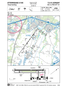


LFEN - Tours Sorigny
Located in Tours, France
ICAO - LFEN, IATA -
Data provided by AirmateGeneral information
Coordinates: N47°15'59" E0°41'57"
Elevation is 299 feet MSL.
Magnetic variation is 0.62° East View others Airports in Centre
Operational data
Special qualification required
Current time UTC:
Current local time:
Weather at : LFOT - Tours Val De Loire ( 18 km )
METAR: LFOT 272330Z AUTO 17008KT 9999 OVC008 10/09 Q1001 TEMPO BKN008 FEW030TCU
TAF: TAF LFOT 272300Z 2800/2824 19012KT 9999 FEW010 BKN020 TEMPO 2800/2805 22013G25KT -SHRA BKN008 FEW030TCU TEMPO 2812/2818 -SHRA FEW030TCU BKN040 PROB30 TEMPO 2813/2816 26015G25KT 4000 SHRA SCT025CB BECMG 2818/2821 13004KT
Communications frequencies: [VIEW]
Runways:
| RWY identifier | QFU | Length (ft) | Width (ft) | Surface | LDA (ft) |
| 04 | 36° | 2297 | 59 | ASPH | 2297 |
| 22 | 216° | 2297 | 59 | ASPH | 2100 |
| 04R | 36° | 1083 | 66 | GRASS | 1083 |
| 22L | 216° | 1083 | 66 | GRASS | 1083 |
Airport contact information
Address: Tours France
Other aviation service providers
Aviation club (not for profit)

Club Rsa Le Sport De L'air Pour Tous
Club Rsa Le Sport De L'air Pour Tous
pruja.laurent@laposte.net0687176457
