


LFEC - Ouessant
Located in Ouessant, France
ICAO - LFEC, IATA -
Data provided by AirmateGeneral information
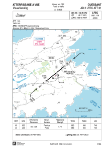
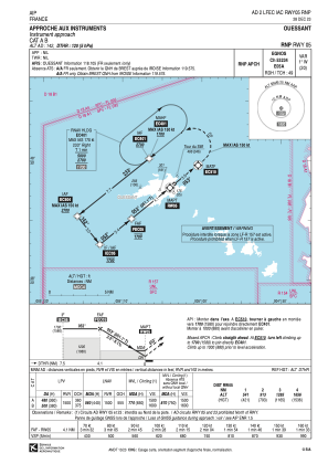
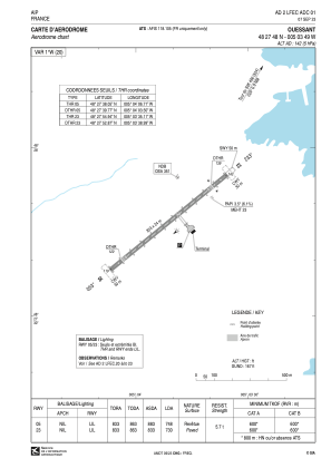
Coordinates: N48°27'48" W5°3'49"
Elevation is 142 feet MSL.
Magnetic variation is -1.35° East View others Airports in Brittany
Operational data
Special qualification required
Current time UTC:
Current local time:
Weather at : LFRB - Brest Bretagne ( 47 km )
METAR: LFRB 291230Z AUTO 20021KT 9999 BKN028 BKN033 BKN043 14/07 Q1014 TEMPO 20020G30KT
TAF: TAF LFRB 291100Z 2912/3018 20015KT 9999 BKN035 PROB40 TEMPO 2912/3006 20020G30KT TEMPO 2919/2921 -RA BKN013 BECMG 2921/2923 OVC013 TEMPO 2922/3010 4000 RA BKN008 PROB40 TEMPO 3006/3009 20020G30KT 2000 RA BKN006 BKN015CB BECMG 3009/3011 22005KT BKN020 TEMPO 3011/3015 4000 RA BKN012
Communications frequencies: [VIEW]
Runways:
| RWY identifier | QFU | Length (ft) | Width (ft) | Surface | LDA (ft) |
| 05 | 51° | 2733 | 79 | ASPH | 2454 |
| 23 | 231° | 2733 | 79 | ASPH | 2395 |
Airport contact information
Address: Ouessant France
